Bentley Systems is advancing its agenda in being a major provider of software and services for the “digital twin” infrastructure economy. The US-based company has acquired Agency9 of Sweden, a boutique firm that has already provided nearly half of Sweden’s larger cities with city-scale digital twin cloud services for city planning and related web-based 3D visualization.
Bentley’s ContextCapture at Agency9
Since 2012, Agency9 has been employing Bentley’s ContextCapture reality modeling software to produce digital twin 3D reality mesh models. This aids cities and towns in visualizing urban infrastructure assets, represented in GIS data, terrain surveys, and BIM models for buildings.
Key Takeaway
More and more cities are seeking a digital twin of their urban reality—a virtuality. This helps them better manage and plan their infrastructure, from roads, bridges to buildings. Agency9’s technology provides a key end-user experience tool that compliments Bentley’s toolsets that build reality meshes for 3D visualization of urban contexts.
Bentley’s new iTwin™ cloud services, introduced recently at a Bentley conference, add digital alignment and change synchronization for infrastructure engineering digital twins, and will enable OpenCities Planner (formerly Agency9 CityPlanner) to uniquely serve urban planning requirements at fuller levels of detail.
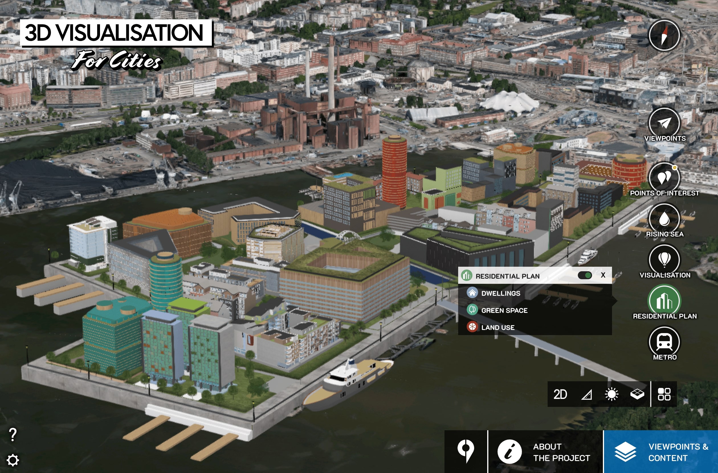
01 – An image of Agency9’s web-based CityPlanner which will now be OpenCities Planner under Bentley.
Phil Christensen, Bentley’s senior vice president, reality modeling said, “Our many city users globally have been asking for the useful capabilities which Agency9 has successfully implemented throughout Sweden, to take further advantage of their reality modeling programs. In fact, when we combine Bentley ContextCapture’s 3D surveying advancements (based on hybrid aerial, UAV, and ground-based imagery) with our Connected Data Environment (CDE) technologies for geospatial-to-BIM integration, we make city-scale digital twins as a cloud service broadly accessible. Ultimately synchronizing reality and ‘virtuality,’ OpenCities Planner offers the perfect web solution to enable every city in going digital.”
Håkan Engman, CEO of Agency9, said, “Now that we’re part of Bentley, we’re confident about achieving the full global potential of Agency9’s innovations. My colleagues and I, and our forward-thinking users in the Nordics have been noted for pushing the envelope of geospatial integration and visual performance to new levels of detail. Now, as contributors toward unique city-scale digital twin cloud services from Bentley, we can foresee the realization of our users’ vision to advance from urban planning to improving cities’ asset performance.”
About Agency9
Agency9 is a leading provider of web and mobile solutions for 3D visualization of geographic information and maps for collaboration and communication. The company was established in 2003 and is headquartered in Stockholm, Sweden. www.agency9.com
Architosh Analysis and Commentary
Architosh first wrote about CityPlanner by Agency9 a little over a year ago. (see: Architosh, “A 3D City Within Weeks—Agency9 of Sweden Can Deliver,” 28 Sep 2017) Their software is web-based and runs on modern web browsers using the technologies of WebGL and HTML5. There is no plug-in needed. Last year we noted that CityPlanner was subscription based and cost EUR 220 per month. There are plans for one, a team, and enterprise.
One of the uses of CityPlanner is the simulation of rising sea levels (see the screenshot above and the software’s controls). You can actually visit a project here. Click on the Visit Project button in blue and it will take you to a Nordic city along the sea. You can then explore the options sea level rise impacts.
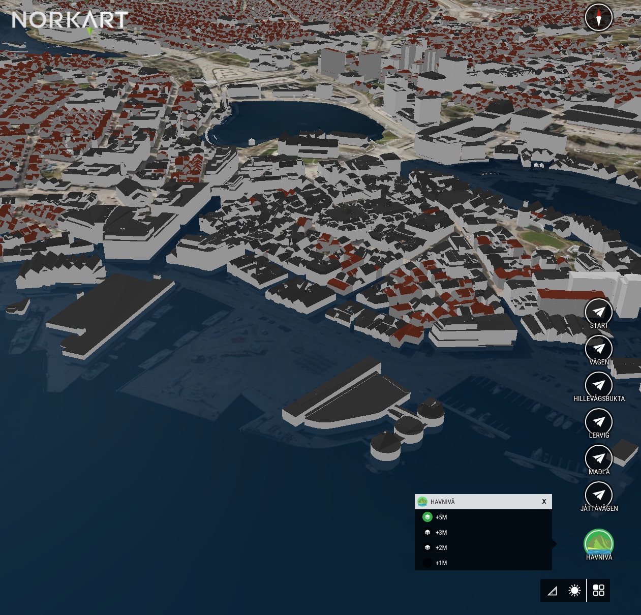
01 – CityPlanner (now Bentley OpenCities Planner) can visualize sea-level rise, a critical infrastructure planning data for municipalities along the coast.
What this acquisition does is marry the technology that Bentley has that has enabled companies like Agency9 to produce such infrastructure reality meshes—3D tech that merges together aerial spatial data, UAV data, and ground-based data to create a single 3D model—into Agency9’s web-based application technology stack.

Reader Comments
[…] Read the article Visit Website […]
Comments are closed.