CloudCities has recently announced a new update to their cloud-based platform that brings procedural terrains into the mix of features for the very first time. The additional new big feature is advanced search capability.
CloudCities is Cloud Platform for Building Insights
CloudCities is aimed at helping AEC clients and their professionals (architects, engineers, builders) learn from their data. It dramatically simplifies the creation of 3D plans that are fused with key data.
MORE: CloudCities Aims To Be the Bridge Between Related Industries—Model Viewing with Data in Mind
It accomplishes this with the integration of spreadsheet-based tools, that architects are already very familiar with for the purposes of handling data workflows, fused to 3D models.
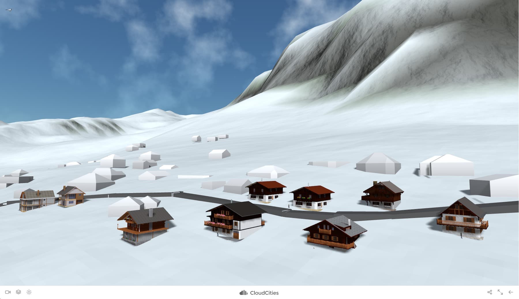
01 – CloudCities update brings procedural based 3D terrains to CloudCities scenes.
With the new version, models can be immersed in beautiful 3D terrains which load extremely quickly as they are entirely generated procedurally. In other words, the terrain modeling is based on algorithms that randomly apply rule sets for terrain generation and variation.
New advanced search brings color mapping. (see image below).
Details on New Features
CloudCities new procedural terrain modeling works by generating the 3D terrain on the fly inside your web browser based on an elevation service (ie: data available through the web that provides elevation contour data per geolocation). CloudCities only needs to download a single light-weight height map image and it will automatically convert this data into complex 3D terrains.
CloudCities can, therefore, present complex and visually attractive terrains in seconds after the viewer opens a 3D scene. Another benefit is that procedural driven terrains can be modified on the fly through texturing based on height map data, showing snowy mountain caps during the winter months and green tips during the summer. CloudCities presents these seasonal adjustments in the scene editor.
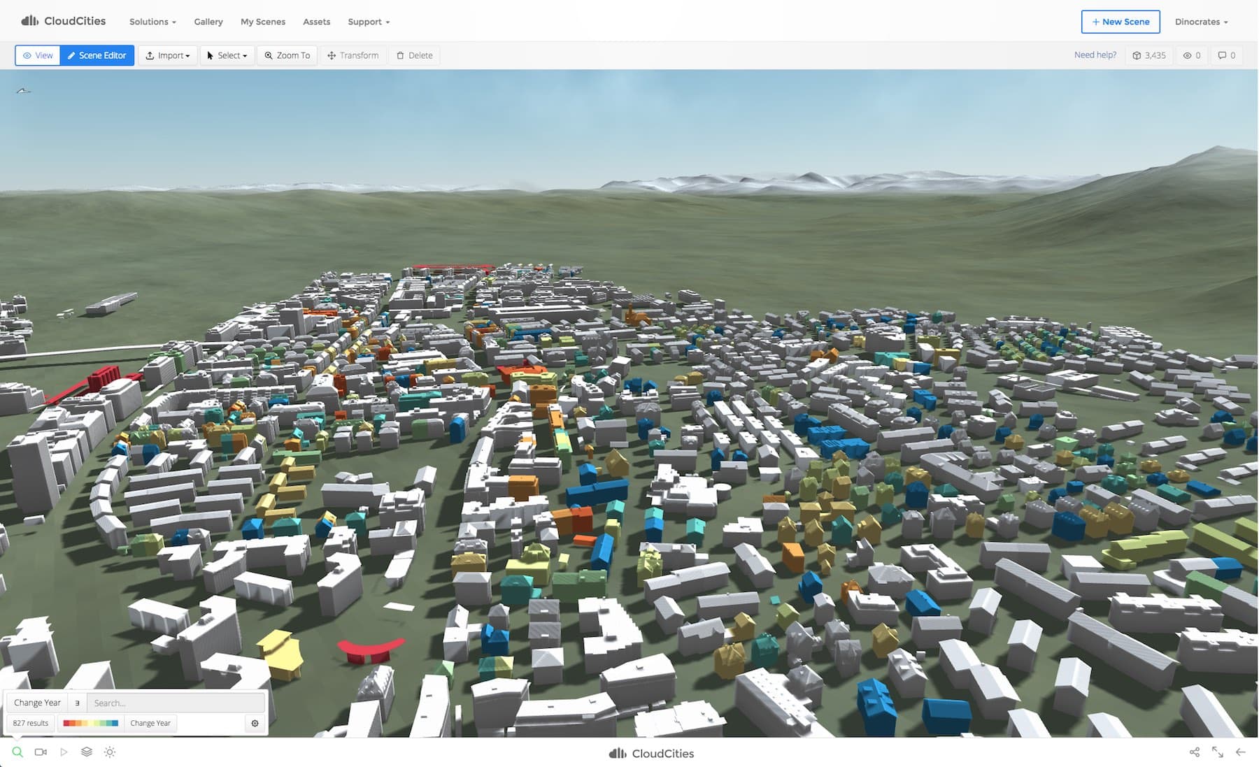
02 – CloudCities now support color mapping for data-driven decision support via color-indexed query results.
The advanced search works while both viewing and editing scenes and come with the following new features:
- Select Highlight Color — the user chooses the highlight color for the search results
- Search specific attributes directly
- Advanced Search Modifiers — (ie: contains, equals, greater than, etc) as well as search ranges
- Combined Search Conditions — (eg: “Building Type equals Apartment AND Build Year > 2000” )
- Apply a color map to the search results
The more complex search operations are hidden from the initial search button and appear only as needed.
Advanced Snapshots and Deep Links
The snapshot feature has now been extended to include search queries. A CloudCities snapshot can contain a camera view, layer settings, date and time settings, as well as a search query. This means that as building change over time, say in campus master planning, a snapshot will update automatically based on the results of the search query saved into the snapshot.
When sharing CloudCities data via its links feature, scenes can now contain additional parameters to set the camera view, layer settings, and data and time settings. Users can share an exact view of a scene by sending a link.
To learn more about CloudCities go here.