One of the main tasks of a surveyor is to measure the surface of the Earth. As it relates to the field of architecture, surveyors also determine the exact position of buildings on a plot of land, while architects determine the exact dimensions of the building itself.
While the roles remain the same today’s new technologies are drastically changing the time it takes to do complex building-related survey work.
From Transits to 3D Lasers
Recently Graphisoft hosted a fascinating webinar titled, “Energizing Heritage Conservation with ARCHICAD Point Clouds and BIM,” led by Philip D. Allsopp, a Chartered Architect of the Royal Institute of British Architects (RIBA).
Phil Allsopp is currently Chief Design Officer and co-founder of Smart Pad Living, LLC as well as Senior Sustainability Scientist and Adjunct professor at Arizona State University’s Global Institute of Sustainability (GIOS).¹
Just prior to the Graphisoft webinar, I had a chance to talk to Allsopp on the phone about subjects such as 3D laser scanning, BIM, and the emergence of HBIM (historical building information modeling), among other things.
The AEC industry is on the cusp of dramatic change in the field—the site of construction. After years of progressive changes brought about by things like the Internet, BIM, and now the cloud, the “cutting edge” in AEC has begun to shift to the outside world with physical innovations like drones and 3D laser scanners.

01 – Philip D. Allsopp, D.Arch., RIBA, FRSA, CSBA, is Senior Sustainability Scientist at Arizona State University’s Global Institute for Sustainability (GIOS). He led a Graphisoft webinar still available for view titled, “Energizing Heritage Conservation with ArchiCAD Point Clouds and BIM.”
“A traditional team would take three months at least and probably cost close to $300,000 dollars, or more,” says Allsopp, referring to the historic Arizona grandstand building his team fully documented using Faro 3D laser scanners, a drone, and Graphisoft’s popular BIM (building information modeling) application ARCHICAD. “If we were doing all of this commercially,” he adds, “it would be somewhere about $45,000 – $50,000 dollars. So it is less than 1/6th the cost of conventional survey methods.”
Saving Heritage Structures
Allsopp isn’t really all that interested in the dollars and sense of this brave new world of drones and lasers; his passion for both the technology and its application is admirably aimed at two separate but yet connected worthy goals—preserving the lives of cultural assets in our built environment and, secondly, fostering the adoption of technologies for simulation and optimization in the AEC industry.
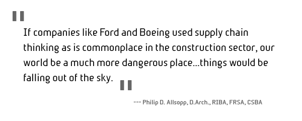
In the opening minutes of his webinar presentation, as well as our talk, this dual focus comes sharply into view. “If companies like Ford and Boeing used supply chain thinking as is commonplace in the construction sector, our world would be a much more dangerous place…things would be falling out of the sky,” says Allsopp. “It’s not just the cost involved in constructing surveys,” he adds, “but when you add this [new technology] to BIM you start to think about how a human habitat can be built if it was built with the same levels of precision and reliability that we currently take for granted in our iPhones and cars.”
Allsopp’s task in Arizona involved spearheading the project for recording the as-built conditions for the historic Arizona State Fairgrounds grandstand building. A consortium of preservation professionals and neighborhood organizations—the Arizona Fairgrounds Stakeholders Group—were at work to save another building on the State Fairgrounds, a treasured yet dilapidated 1938 WPA Administration Building, from demotion to be replaced by blacktop parking spaces. During their analysis of the site, Stakeholders Group discovered that the grandstand had no record drawings describing the structure, its dimensions, and plans. For future preservation and repair work, as-built drawings of the huge structure were needed.
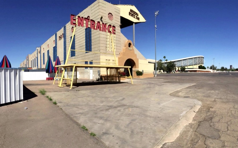
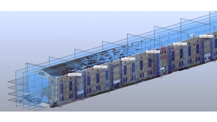
02 – The historic grandstand building at the Arizona State Fairgrounds in Phoenix, Arizona. Allsopp’s collected team is submitting NABS Standard based drawings to the Library of Congress derived from a “point cloud to BIM” workflow process from FARO to Graphisoft ArchiCAD 19. (image: courtesy of Philip. D. Allsopp. All rights reserved.)
“Arizona doesn’t need anymore of that,” says Allsopp. Noting that blacktop paved parking lots in an environment like Arizona contributes significantly to what environmental scientists and urban planners know as the “heat island” effect. While rooftops actually contribute more area than paving and roads, (up to 30 percent of urban area) both surfaces contribute greatly to the phenomenon that urban areas can be up to 7 degrees hotter than the nearby rural areas that surround them.
This excessive heat in urban areas forces buildings to work harder and longer to provide air-conditioned and cooled environments that people can be productive in. Hence, Allsopps’ involvement in a preservationist project is instantly linked back to his interest in sustainability in the built environment and the design of places that are much more efficient and that enable and encourage healthier living.
next page: BIM and HBIM—No Distinction Necessary
BIM and HBIM—No Distinction Necessary
The grandstand survey project maybe a preservationists objective, yet the way Allsopp looks at the project in general is much informed by his background. “Back in England there was no sharp difference between heritage preservation and revitalization of existing structures,” he adds, “for me I don’t distinguish historic preservation from the act of creating great places for a wide range of human endeavors, whether these places are new buildings or existing ones.”
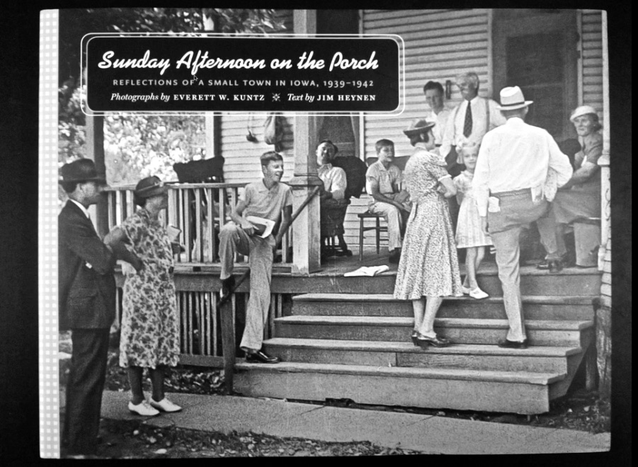
03 – The adaptive reuse of historic buildings is a key element maintaining our cultural heritage. Scenes like this were where social capital was and still is generated.
Allsopp notes that since WWII, land speculation and the conversion of human habitats have turned real estate into commodities. As a result, worthwhile old neighborhoods, parks, squares, culture facilities, and even the simple porches on homes have come under threat due to myopic, dollar-driven decision making. Pointing to a webinar slide of a wonderful Americana neighborhood porch scene from the early 20th century, Allsopp observes: “These are the places where social capital grows and as any economist will tell you it is social capital that drives innovation and economic growth.”
Preserving the use of older buildings and places, particularly ones that foster social capital, fits hand and glove with endorsing the technologies that will make buildings have a smaller environmental impact on the planet. “HBIM, or historical building information modeling,” says Allsopp, “is the use of BIM technology to document, simulate, and improve the performance of existing structures.”
Not only does it cost the environment more “embodied energy” to produce the materials needed for a brand new building, versus what is required for adaptive reuse of historic and meaningful older architecture, but heritage buildings can be refurbished to become leaner, energy sipping environments for human occupation. From this perspective, BIM becomes a crucial tool, as sophisticated energy simulations and optimization requires 3D models.
First Step, Save It—Second Step, Record It
Not all historic structures are worthy of being saved and retooled for a more carbon-friendly life. While Allsopp and others have been determined to save the Arizona State Fairground grandstand building, in the end its final outcome may come to destruction.
04 – FARO 3D laser scanners are leaders in the industry and the company also produces software to post-process the billions of data points in point clouds. (image: courtesy of Philip. D. Allsopp. All rights reserved.)
As part of the process of saving this historic structure, Allsopp’s team setup task to fully document the existing structure to HABS Standards. HABS stands for Historic American Building Surveys.
The process consisted of scanning the 500 foot plus long structure over a four day period using Faro 3D laser scanners being led by the firm ToPa3D along with Allsopp’s Smart Pad Living team. From the Faro 3D laser scans the point-cloud data would go through a software clean-up process and then finally be imported into Graphisoft ARCHICAD 19. A drone unit with a camera was also deployed to capture photographic imagery. A team of 6 people, including Allsopp himself, took 4 days of 3D laser survey work, plus 2 weeks post-processing of point-cloud data and then one month of work in ArchiCAD to produce historic survey drawings that meet the US government’s HABS Standard before being submitted to the Library of Congress.
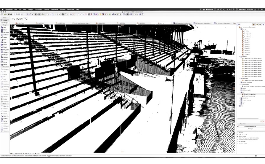
05 – A point-cloud image inside ArchiCAD 19 of the Arizona State Fairgrounds grandstand building. (image: Philip Allsopp, All rights reserved.)
“The Library of Congress now wants the point-cloud data itself,” says Allsopp, “on a compact disc or DVD to be delivered to the Library of Congress, along with the HABS 24×36 inch standard drawings.”
Faro to ArchiCAD
Over the course of four days there were well over 300 scans. Because you must take scans of the structure from multiple points so that the laser light can penetrate every side and aspect of a structure, in the end all these scans must be reconciled in software. Faro makes its own software for this process which, in addition to cleaning up dust—as dust particles can be mistaken for elements of a structure—it helps average out multiple X-Y-Z points that stand for the same point in space.
“You end up having like five data points for everything,” says Allsopp, “so smart algorithms clean up the mess and discharge unneeded X-Y-Z’s.” Faro 3D lasers produce point clouds with plus or minus 2mm accuracy. “Over 100 billion data points were created on this project,” says Allsopp, “but in the end it was 4 billion data points that were brought into ArchiCAD quite easily.”
06 – Another image of a complex point cloud in ArchiCAD 19. The BIM software can easily import massive point cloud data.
Since the actual point-cloud data is much like a real cloud made of trillions of particles of water, it very much acts just like a solid object in 3D space, just one made of billions of finite points with air between. As an object then, within ArchiCAD one can setup views and building stories that cut through the point cloud. “This helps in creating cut planes for floor plans, sections, and elevations.” says Allsopp.
The Webinar
The entire process of digitally surveying the historic Arizona State Fairgrounds grandstand building using 3D lasers and drones and ArchiCAD is explained in more detail inside the free Graphisoft webinar, “Energizing Heritage Conservation with ARCHICAD Point Clouds and BIM.” We encourage readers to sign-up and watch the webinar on their own schedule. Items of note include:
- Information on Faro 3D laser scanners and their inner workings
- The physics of light as it relates to gravity fields (force of gravity on light) and how devices like lasers and even cell phones and must account for it
- Some history on the formation of HABS
- How ArchiCAD was used to create HABS Standard based 24×36 in. drawings
- Why the US Government wants point-cloud data itself
- Why Allsopp thinks of BIMx as a 21st Century printing press
To learn more go here.